Skip to content

Field book, vol. ip. i

Field book of

Far Meridian Out past the margin.

Small groups on foot through the Ikara-Flinders Ranges, overland to the salt country, and south to Antarctica with a small expedition ship. We go slowly, and we write it all down.

Read the Ranges Write to us

A drawn rangep. ii

A long quartzite ridge in early light, four walkers small on its crest, one in a hijab

these lines aren’t ruled. they’re ground.

a drawn range · one rule to every 20 m

turn the page

Contentsp. 1

Contents

  1. I.The Ranges, on foot3
  2. Six days, side on9
  3. II.The salt country, overland11
  4. III.The Ice, by small ship13
  5. Going ashore17
  6. What goes in the pack19
  7. How a journey starts21
  8. Write to us23

Acknowledgement of Country

We work from Adelaide, on Kaurna Country. Our walks in the Ikara-Flinders Ranges cross Adnyamathanha Country, and the salt country around Kati Thanda-Lake Eyre is Arabana Country. We travel there as visitors, and we pay our respects to the Traditional Owners and their Elders, past and present.

The keyp. 2

How to read these pages

  • contour, 20 m
  • index contour, 100 m
  • route walked
  • route ahead
  • camp, stamped with its day
  • water we left ahead
  • spot height
  • shore
  • waterline, below the sea

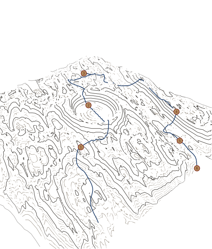
The land on these pages is drawn in your browser from a seeded noise function. It is drawn for this page, after the Flinders but not a map of them, and it is not for navigation. Every distance and climb in the log is measured on the drawing. There are no names on the map: the camps are numbered.

I. The Ranges, on footp. 3

I. The Ranges, on foot

The Ikara-Flinders Ranges are Adnyamathanha Country. We walk as guests, on tracks open to walkers, and we leave it as we found it.

Six days walking, a creek in and a creek out, with a ringed basin in the middle. Before we start, we leave water ahead of us, and we carry the rest.

Day 1 · The creek in

Day 01 · D-18 to H-12 · 7.1 km · 320 m up · water 6 l · wx calm

Away from the vehicles by 08:00. Six litres each for today; the rest went ahead yesterday to the drop at the Day 3 camp. The creek is dry sand and river stones under river red gums, easy walking and cool in the shade. Corellas in the gums, loud about it. Camp on a terrace above the bed by 15:00.

11:40 · water check · 3.5 l left

corellas. all night. worth it.

Day 2 · Up to the rim

Day 02 · H-12 to L-09 · 7.6 km · 890 m up · water 5 l · wx NW 10

The first climb. Quartzite underfoot, the strata tilted like a shelf of books, and slow going on the loose parts. From the rim the whole basin opened below us in one piece, and nobody said much for a while. Then down the inside slope, through native pines, to camp on the flat by 16:00.

12:50 · on the rim · long stop, 2.5 l left

Day 3 · The north gap

Day 03 · L-09 to P-04 · 8.9 km · 740 m up · water 4 l · wx W 15

Out through the gap at first light. Cold in the shadow of the ridge, warm the moment we stepped out of it. Two euros on the scree above us, watching us the way we watched them. Lunch on the saddle: flatbread, dates, oranges. The water we left was waiting at camp, and tomorrow’s packs are heavier for it.

15:30 · the drop at camp · all bottles full

the rim goes red just before the light does. look back.

Day 4 · The long ridge

Day 04 · P-04 to P-15 · 13.5 km · 1,170 m up · water 5 l · wx W 25

The long one on the map, and it looks longer from the bottom. Up onto the crest early and along it all day, with the wind from the west all morning. We stopped at noon on a flat rock for prayer and a long rest, then tea. Camp on the shoulder by 16:00. Tea by ten past.

12:00 · flat rock · prayer, then tea · 2 l left

Day 5 · Down the gorge

Day 05 · P-15 to N-17 · 3.7 km · 130 m up · water 4 l · wx calm

A short day on purpose. Off the shoulder and down into the gorge, in shade most of the way. Pools from last month’s rain, and we stepped around them. Yellow-footed rock-wallabies on the far wall, well above us and not bothered. Camp early, boots off, and a long afternoon with the notebook.

10:40 · the far wall · rock-wallabies, left be

Day 6 · The creek out

Day 06 · N-17 to L-19 · 3.3 km · 60 m up · water 3 l · wx calm

Sand and gums all the way back to the vehicles, the creek running south and us with it. The carried water lasted, just, and the last litre went into the kettle at the tailgate. Packs off, boots off, one more cup before the long drive. Home to Adelaide by evening.

12:20 · the tailgate · last litre in the kettle

nobody talked on the way out. didn’t need to.

Sheet 1 · a drawn range · contour interval 20 mp. 4

D-18 · 320 m

N ↑ · contour 100 m · 0 — 2 km

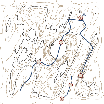
A traced contour map of the drawn range, the six-day route drawn on it and each camp stamped with its day
  1. 1
  2. 2
  3. 3
  4. 4
  5. 5
  6. 6

A range drawn for this page, after the Flinders. Distances are measured on the drawing. Not for navigation.

Arrow keys look around. Escape returns to the route.

Section A–A′p. 9

Six days, side on.

Four walkers in single file along a dry creek bed under tall river red gums
creek bed, day 1

The whole walk, side onp. 10

An enamel kettle steaming on a gas stove beside two mugs of tea and a folded map on red earth
the kettle goes on before anything else

Section A–A′ · the Ranges route, west to east and backVertical exaggeration ×10

Section A to A prime: the height of the whole route, from 270 m to 960 m, with each day’s camp marked200 m300 m400 m500 m600 m700 m800 m900 m1000 m0 km5 km10 km15 km20 km25 km30 km35 km40 kmAA′123456

carry the extra litre.

Six days, 44.1 km and 3,310 m of climbing in all, measured on the drawing. Day 4 is the long one.

II. The salt country, overlandp. 11

II. The salt country, overland

Day 1 · Out of the hills

Day 01 · 190 km by road · 0 m up · water 6 l · wx N 20

North out of the Ranges in two four-wheel drives. The ridges drop behind us one at a time, and the road straightens until it stops bending at all. We check the water twice, once at lunch and once before camp, and sleep on red sand with nothing between us and the horizon.

Day 2 · Gibber

Day 02 · 160 km by road · 0 m up · water 6 l · wx calm

Gibber plain: polished stones to the horizon in every direction, dark red and shining. We stop the engines at noon and stand in the quiet. No birds, no wind, no sound but boots on stone. The track is easy to lose out here, so the two vehicles stay in sight of each other.

Day 3 · The shore

Day 03 · 70 km by road · 0 m up · water 6 l · wx calm

We stop on the shore of Kati Thanda-Lake Eyre at first light and look. We don’t drive on the lake. White salt to a flat horizon, and in the low sun the crust goes pink. A short walk along the firm edge, then back to the shore for tea.

Sheet 2 · the salt countryp. 12

White salt crust to a flat horizon, a line of footprints leading to two small walkers

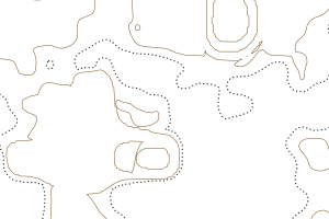
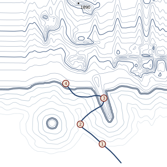
N ↑ · contour interval 20 m

A traced contour map of the salt country: two contour lines and a dotted pan shore on an almost empty page

no contour lines for a whole day’s drive. we checked.

From here the pages are white.

Two days of Southern Ocean between the last brown page and the first white one. We travel with a small expedition ship. Antarctica is set aside for peace and science under the Antarctic Treaty, and we keep to that: we leave nothing, take nothing, and keep our distance.

III. The Ice, by small shipp. 13

III. The Ice, by small ship

Four pages from a voyage south: a crossing, a bay, and two landings. The ship’s days are planned around the weather, and we go ashore only when it says so.

At sea

At sea · wx SW 30, swell 4 m

Two days of it. The first albatross, the first iceberg on the radar, and then out of the window. We keep a watch from the bridge wing in turns, wrapped up, and the notebook lives in an inside pocket where the spray can’t reach it.

06:10 · bridge wing · first iceberg by eye

First ice

The bay · wx calm · brash ice

The swell drops away behind the island and the bay goes still. Brash ice ticks along the hull. Somebody spots a seal asleep on a floe, and we watch it from a long way off, and leave it sleeping.

09:30 · the bay · one seal, asleep, left asleep

Ashore at the point

Landing 1 · 1.0 km ashore · snow, then rock

Ashore in small boats, boots scrubbed at the gangway and again on the way back. Up the snow onto the rock of the point, slowly, on the line the guides marked. From the top, the whole bay: the ship small at anchor, and ice to the horizon.

08:15 · the gangway · boots scrubbed, into the boats

snow that squeaks.

Ashore in the bay

Landing 2 · 1.6 km ashore · rock, then snow

A shorter landing at the head of the bay. A glacier cracks somewhere out of sight, and nobody sees where. We stand with the sound for a while, then walk back down to the boats and count everyone twice.

15:40 · back at the boats · counted twice

Sheet 3 · a drawn coast · contour interval 50 mp. 14

L-16 · sea

A small boat of travellers heading ashore in an Antarctic bay, a plain ship at anchor among icebergs

N ↑ · contour 100 m · 0 — 2 km

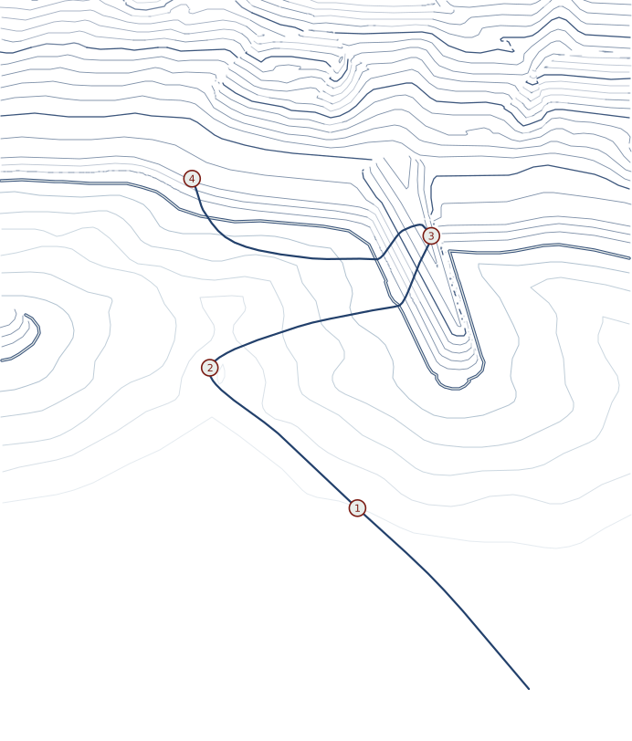
A traced contour map of the drawn coast, waterlines off the shore, the ship’s track and both landings
  1. 1
  2. 2
  3. 3
  4. 4

A coast drawn for this page. Contours every 50 m on the ice and waterlines every 20 m below the sea. Not for navigation.

Arrow keys look around. Escape returns to the route.

Going ashorep. 17

How we go ashore.

  • Boots scrubbed before and after every landing.
  • Nothing left, nothing taken, not a stone.
  • We keep well back from penguins and seals and let them choose the distance.
  • No drones near wildlife, ever.
  • We go ashore in small boats and walk only where the guides have marked.
  • The ship’s day is planned around the weather, and the weather decides.

Landing 1, from the snowp. 18

A penguin colony small on a dark shingle beach, seen from far up the snow, where three travellers stand well apart and well back
they chose the distance. we stood still.

What goes in the packp. 19

What goes in the pack.

We carry

  • tents and swags
  • the gas stove and fuel
  • water, and the drops ahead
  • the first-aid kit
  • maps

You bring

  • boots you’ve walked in
  • long sleeves and long trousers
  • a brimmed hat
  • a warm layer for the night
  • your own medicines

Leave behind

  • drones
  • anything you’d mind losing to red dust

And for the Ice

Waterproofs, layers, gloves. Ask us what the ship lends for landings.

Campp. 20

How we keep camp

Tea and water at camp. We cook on a gas stove, not a fire.

Our camp kitchen cooks halal-friendly food, and there is no alcohol at camp. Tell us how you eat (halal, vegetarian, anything else) and we plan the kitchen around it.

Prayer times go into the day’s plan if you ask.

Headscarves and hijab sit well under a wide brim; we carry a spare hat.

the sun decides what you wear.

How a journey startsp. 21

How a journey starts.

  1. Write to us.

    Tell us which journey and roughly when.

  2. Tea in Adelaide, or a call.

    We go through the route, the fitness it asks for, and the kit.

  3. The journey.

    We write the notebook as we go.

  4. Afterwards.

    A copy of the notebook page with your route on it.

Each journey on these pages is a sample. We plan every one with the people going.

Questions we get askedp. 22

How fit do I need to be?

If you can walk for five or six hours on uneven ground with a day pack, you’ll manage the Ranges. We go through each day’s climb with you before you decide. The Ice asks for less walking and more patience.

What is the weather like?

In the Ranges, cool mornings and warm afternoons from autumn to spring; we don’t walk there in summer. On the Ice, anything from bright calm to wind and snow in the same afternoon.

Can I come on my own?

Yes. Tell us when you write, and we’ll plan your tent, your seat in the vehicle and your cabin on the ship with you.

What happens if it rains?

We wait it out, or we change the route. Creeks in the Ranges can run after rain, and we never cross one that’s flowing. The notebook has pages for rain days.

Where do we start from?

The Ranges and the salt country start from Adelaide, by vehicle. For the Ice we meet you at the port the ship sails from, and we’ll tell you which when we plan it together.

Write to usp. 23

Write to us.

What you write here stays on this page.

However you’d like us to answer.

Which journey

Halal, vegetarian, anything else. We plan the camp kitchen around it.

Fitness, a knee, prayer times, questions.

Endpaperp. 24

The whole six-day route on one traced contour map of the drawn range, every camp stamped
The whole walk, on one page

Set in Courier Prime and Caveat. The range and the coast on these pages are drawn in your browser from a noise function; they are not surveyed, and every distance is measured on the drawing. The photographs were made for this page.

We work on Kaurna Country, and walk on Adnyamathanha and Arabana Country, as visitors.

End of notebook

Far Meridian · Adelaide · If found, please return.